

A few days ago a team from the National Geophysical Research Institute, Hyderabad rushed to drought-hit Latur to team up with an NGO to drill 100 borewells.
The NGRI team was expected to identify locations where underground water is still present and can be tapped. Unfortunately, the locals who had misgivings about the project, shooed away the survey team from NGRI and the NGO.
“This would not have happened if the government had gone ahead with the 3D scanning of subsurface across the country. We have done a pilot study of 2,500 sq km. If the mapping was done, I could have given the Latitudinal & Longitudinal coordinates for drilling the borewell,” says Shakeel Ahmed, Chief Scientist at NGRI.
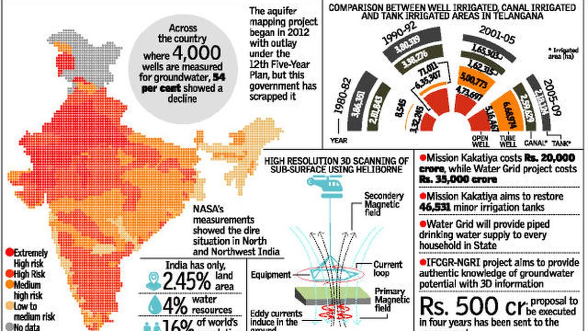
“The aquifer mapping project began in 2012 with outlay under the 12{+t}{+h}Five-Year Plan but this government has scrapped it focussing on cleaning up the Ganga and other projects. India has only 2.45 per cent land area, 4 per cent water resources and 16 per cent of world’s population. Unless we know where we have water and take proactive measures, we will have this desperate scenario every year,” says Mr Ahmed ominously.
Only last year, the US space agency NASA raised an alarm over the sharp decline in groundwater table across north India.
Using two satellites that measured minute shifts in earth’s gravitational pull linked to mass, NASA’s scientist Matt Rodell released his findings to show the precipitous decline in groundwater table in Punjab, Haryana, Rajasthan and other northern States.
Earth's gravity measured
Using NASA’s twin GRACE (Gravity Recovery and Climate Experiment) satellites, the scientists measured tiny shifts in earth’s gravity field to determine the rate of groundwater change in India between 2002 and 2008.
Areas in red had slightly less mass due to a net loss of groundwater and therefore exhibited a weaker gravitational pull on the orbiting satellites.
Blue showed where the water level has not declined.
NASA’s measurements showed the dire situation in North and Northwest India.
A World Resources Institute’s collaborative online tool shows the crisis across the country using data from Central Ground Water Board (CGWB). Indiawatertool.in has the data up to 2015 and it is not a pretty picture with depleted groundwater level in most urban areas and the densely populated southern India.
Across the country where 4,000 wells are measured for groundwater, 54 per cent showed a decline, according to a figure by CGWB.
The situation is likely to get worse if we don’t do something about it.
“The decline in groundwater is due to climate change. While the Met Department says the monsoons are normal and the rainfall is sufficient, the number of rainy days has declined. Only if it rains for more number of days does the water replenish the aquifer. Now, we have to recharge the groundwater artificially and we have the technology to locate where it can be done. And it is no longer an option, but has compulsory,” says Mr. Ahmed.
The data shows depletion of water levels in densely populated areas
in South as well
