
The highest daily rainfall in a century. Freak weather conditions on one day. The hottest-ever Indian Ocean. The strongest-ever El Niño. The hottest year on record.
The bad news is that a perfect storm of meteorological conditions combined to create Chennai’s worst-ever deluge last week, exacerbated in no small part by civic infrastructure pushed to its limit and systemic dysfunction. The worse news is, that could happen again, and soon; 2015’s El Niño is on course to being the strongest ever recorded.
The El Niño is a weather phenomenon resulting in warmer than expected ocean temperatures in the central and eastern parts of the tropical belt of the Pacific Ocean.
Parts of this oceanic zone have already hit record temperatures this year, setting the 2015-16 El Niño well on its way to a record intensity, with potential impacts across the world encompassing the range of events, including searingly high temperatures, droughts and intense rainfall.
Chennai’s wettest season comes in hottest year
On December 1, 2015, freak weather conditions all came together on one single day to swamp Chennai with the heaviest rainfall in a century. If that was bad news the worse is that it could all happen again. The World Meteorological Organisation has been producing regular updates on the scale of this year’s El Niño, and its expected impact was a significant contributor to the India Meteorological Department’s forecast of a deficient south-west monsoon, a forecast that was spot on.
The same weather system was also expected to have an opposite impact on the north-east monsoon — the one that southern India experiences in its winter months — but the impact on the southern monsoon is much less clearly established, said G.P. Sharma, vice-president of meteorology with the private forecaster Skymet Weather.
A positive Indian Ocean Dipole — warmer sea temperatures in the western Indian Ocean and a cooler eastern Indian Ocean — kept ocean temperatures high in the south Bay of Bengal resulting in strong weather systems in the South Andaman Sea, Skymet Weather assessed.
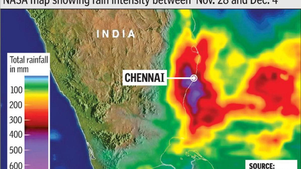
![]() What happened on December 1, however, when clouds dumped up to 490 mm of rain on parts of Chennai over 24 hours went beyond El Niño. El Niño affects the whole season and is not responsible for individual episodes of intense rain, according to B. Mukhopadhyay, additional director-general of meteorology (research), IMD (Pune). “An individual episode like that on December 1 is a combination of several factors and in every such episode, the combination changes. On December 1, the lower-level moisture supply was high and upper air evacuation of the moisture was also strong. We call this phenomenon upper air divergence, and the effect is that the cloud becomes very intense. Both coincide very rarely,” he said.
What happened on December 1, however, when clouds dumped up to 490 mm of rain on parts of Chennai over 24 hours went beyond El Niño. El Niño affects the whole season and is not responsible for individual episodes of intense rain, according to B. Mukhopadhyay, additional director-general of meteorology (research), IMD (Pune). “An individual episode like that on December 1 is a combination of several factors and in every such episode, the combination changes. On December 1, the lower-level moisture supply was high and upper air evacuation of the moisture was also strong. We call this phenomenon upper air divergence, and the effect is that the cloud becomes very intense. Both coincide very rarely,” he said.
At the same time, 2015 is on course to being the hottest-ever year recorded both globally, and as was recently confirmed by the IMD. The same holds for ocean temperature. The United States’ National Oceanic and Atmospheric Administration has established that the Indian Ocean’s temperature in October 2015 was the record hottest.
“One of the most confidently predicted consequences on warming land and oceans is an increase in evaporation that could provide more fuel for more intense rainstorms on land. The recent extreme rains in Chennai surely seem to fit that trend,” the U.S.-based meteorologist, Eric Holthaus, explained in an email to The Hindu .
Such episodes of intense episodic rainfall are only going to become more frequent. In 2009, an Indian Institute of Tropical Meteorology study found an alarming rise in the number and intensity of “extreme point rainfall events” and the 2011 Intergovernmental Panel on Climate Change, too, predicted an increase in the probability of extreme weather events as a result of climate change.
If these phenomena explain to some extent the intensity of the rainfall, the flooding is also substantially explained by the civic disrepair that has left nowhere for the water to go, and little means of conveying information.
On December 2, PWD officials were releasing 30,000 cusecs from the Chembarambakkam reservoir. Consequently, the Adyar was in spate, flooding most parts of the southern and even central parts of the city. PWD officials insist that the discharge was necessary as they could not afford to risk the safety of the reservoir.
While the flooding of the southern parts is recurring during winter, the flooding in the heart of the city exposed the government’s unpreparedness in anticipating the floods based on water release into the Adyar and in disseminating information in advance for the residents to act.
The worst affected were the southern suburbs that witnessed an unplanned real estate boom in the last decade with unapproved layouts springing up adjacent to wetlands and water bodies. Since the panchayats are unable to regulate unauthorised construction, residential development in low-level areas has mushroomed. Since the channels are also blocked, the inundation lasts longer.
Some time ago, there was talk of delineating river corridors and mapping of flood plain zones to enable the residents to know the flood risk factor of their localities but it did not materialise.
Added to this was the inadequacy of drains. Most parts of the old city were relatively safe from flooding this time. Of the Corporation’s area, the 172 sq. km of the old city have storm water drains while the remaining 254 sq. km have no storm water drains but only drains constructed by the local bodies that are not connected to the rivers.
As of now, civic officials say the storm water drains could handle only 3 cm of rainfall an hour. With expertise from the Netherlands and other European nations, they are working on a design to handle 6.8 cm of rainfall. The city is also getting World Bank funding to the tune of Rs. 1,000 crore for developing watersheds in the Adyar and Cooum basins. Thirty-nine packages have been finalised, and work orders issued. Work on the Kosasthalaiyar and Kovalam basins has been delayed as no agency has come forward to fund the projects, officials say.
IMERG data shows rainfall that fell from November 28 to December 4, 2015 reached over 400 mm (15.7 inches) of rainfall in areas south of Chennai.
Click here for full coverage of the Chennai floods
Published - December 07, 2015 02:03 am IST
