

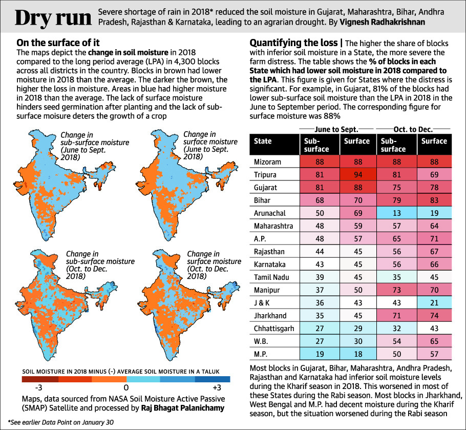
Severe shortage of rainfall in 2018 reduced soil moisture across several States. This has led to weaker or sparser vegetation.
No green shoots
The map depicts the change in vegetation in 2018 compared to the mean vegetation between 2010 and 2017, in 4,449 blocks across all districts in the country. This change is called NDVI anomaly.
Blocks in red had sparser or weaker vegetation in 2018 than the mean. Blocks in green had thicker or healthier vegetation in 2018 than the mean. Blocks in yellow had negligible change in 2018 from the mean. Sparser vegetation means that the quantity of crops is affected. Weaker vegetation means that the quality of crops is affected.
The blocks with NDVI anomaly in red mostly match with those which had inferior soil moisture ( see earlier data point dated February 6 ).
What is NDVI?
The Normalised Difference Vegetation Index* (NDVI) is used to measure the health and vitality of vegetation. Healthy or dense vegetation reflects more near-infrared light (NIR) but less red light (RED) as chlorophyll absorbs RED.
On the other hand, if the vegetation is weak or sparse, the NIR reflection is less and the RED reflection is moreThe NDVI combines these two reflections into one value using the following equation:
NDVI=(NIR-RED)/(NIR+RED)
This value will always be between +1 and -1. A positive value indicates healthy or dense vegetation and a negative value indicates the opposite.
We calculated the NDVI value for June to December 2018 (both the Kharif and Rabi seasons) and compared it with the mean NDVI value for the same months from 2010 to 2017.
Quantifying the difference
The higher the share of blocks with sparser or weaker vegetation in a State, the higher the possibility of farm distress. The table shows the percentage of blocks in each State which had sparser or weaker vegetation in 2018 compared to the 2010-2017 mean.
For example, in Gujarat, 70% of blocks had sparser or weaker vegetation in 2018 than the mean. This shows that the crops in those blocks in 2018 either lacked the quality achieved or were lower in quantity compared to the mean period.
| State | % of blocks with sparse vegetation |
|---|---|
| Gujarat | 70.2 |
| A.P. | 66.8 |
| Chhattisgarh | 64.6 |
| Maharashtra | 56.2 |
| Kerala | 52.4 |
| M.P. | 49.6 |
| Odisha | 47.7 |
| Manipur | 40 |
| India avg. | 38.2 |
| Nagaland | 36.4 |
| Karnataka | 26 |
| Jharkhand | 25.8 |
| U.P. | 22.7 |
| Bihar | 21.2 |
| Arunachal | 18.8 |
| Rajasthan | 15.1 |
| Tamil Nadu | 9.7 |
| J&K | 7.1 |
| Himachal | 5.3 |
| Uttarakhand | 5 |
| West Bengal | 4 |
| Assam | 1.2 |
Pinch of salt
While the lack of soil moisture is an accurate indicator of drought, NDVI anomaly is not. For example, 52% of the blocks in Kerala had sparser or weaker vegetation in 2018 than the mean despite heavy rains. This is because floods too affect vegetation as they reduce crop area.
Maps, data sourced from MODIS (NASA EOSDIS LP DAAC) and processed by Raj Bhagat Palanichamy
